YOUR TRUSTED PARTNER IN MARITIME SOLUTIONS

Image

Why GreenFinder?

GreenFinder supports our customers from the beginning with the end in mind, from initial purchase all the way into the distant future. Through regular software updates, our systems protect customers' investments and ensure the latest technology. With our dedicated team of specialists, GreenFinder’s thinking edge gives you confidence through complete control over the safety and security of your maritime operations.

Whichever solution you choose, GreenFinder works diligently to build a long-lasting relationship and offers uncompromising support.

OUR SPECIALITIES

Greenfinder has over the years gathered the strength of local experienced personnel whom had acquired their expertise from foreign strategic business partners through technology transfer and field experience to finally crystallize a credible and capable team to undertake bigger future challenges.

MetHydro via AIS

We offer real-time Met/Hydro systems for docks, ports, harbor and fairway, marine terminals and offshore, as part of our standard system deliveries.

Remote Monitoring System

Our solution can automatically acquire battery voltage, lantern current, and lantern on/off data, and sends it as an addressed binary Message 6 to the AIS management center.

Marine Lanterns

From 2nm to 24nm ranges, we can supply the lantern most suitable for your requirements. As part of any lantern supply, we assist with the programming of the units, the design of power supplies and offer installation and maintenance services.

Nationwide AIS

The Automatic Identification System (AIS) was conceived as a means of communicating the position and identity of ships to shore and to other vessels.

Dredging and Dumping Monitoring System

Dredging and Dumping Monitoring System is used to monitor the movement of Spoils Dumping vessels and detect any illegal dumping within the area covered by National AIS Network.

DGNSS / DGPS reference & Monitoring Stations

The basic concept of a DGNSS broadcast site is to collect GPS signal data at known Reference Station location, calculate the errors on those signals based upon known site information, and broadcast those errors (in the form of corrections) to ships fitted with Differential GPS receiver.

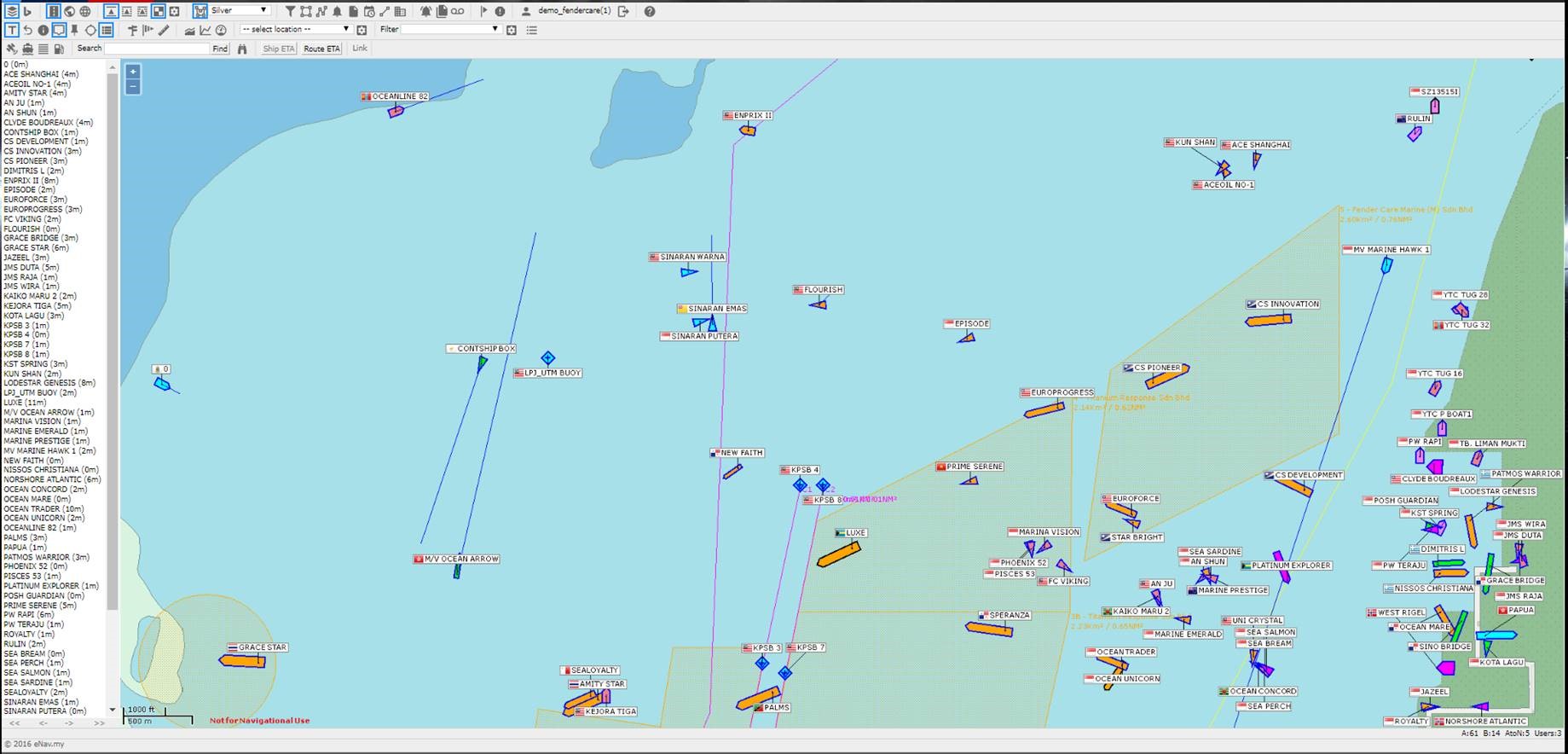
eNav.my - Take Control of Your Operation!

  • Visualization tool supporting Maritime Domain Awareness
  • Controls to display only the information that is important to your organization
  • Fully web-enabled to support a diverse group of users
Image

Major Customers

The company has served a wide base of clientele both in the government and private sectors. The company has established an excellent working and long-term relationship with most of these clients where the customers have continued to support us where it's continually offered new job opportunities.

Jabatan Laut Malaysia
Lembaga Pelabuhan Bintulu
Port of Tanjung Pelepas
Maritim Malaysia
Maritim Malaysia
Lembaga Pelabuhan Johor
Johor Port Berhad
Johor Port Berhad
Pusat Hidrografi Nasional
Jabatan Ketua Pengarah Tanah dan Galian
Pengerang Deepwater Terminals